Central Meteorological Observatory: Typhoon Sura tends to the eastern part of Guangdong to the southern coast of Fujian, so it is necessary to guard against the influence of typhoon wind and rain.
CCTV News:According to the WeChat official account news of the Central Meteorological Observatory, Typhoon Sura will enter the northeastern part of the South China Sea on the morning of August 31st, and its intensity will increase again, and it will gradually approach the eastern part of Guangdong to the southern coast of Fujian. It may land on the eastern coast of Guangdong from the night of September 1st to the morning of September 2nd (typhoon level or strong typhoon level), or it may move to the south-west direction in the coastal waters of eastern Guangdong. Typhoon Anemone will begin to affect the eastern waters of China on the night of September 1st.
Influenced by the interaction between Typhoon Sura and Anemone, there is still great uncertainty in the later stage of Sura. The Central Meteorological Observatory will pay close attention to the trend and influence of typhoon and continuously update the forecast conclusions.
Typhoon forecast
This year’s No.9 typhoon "Sura" was generated on August 24th. At 14: 00 this afternoon (29th), its center is located on the ocean surface about 410km southeast of Taiwan Province, and the maximum wind force near the center is 15 (48m/s, strong typhoon level).
It is estimated that "Sura" will move to the north-west direction, enter the northeastern South China Sea on the morning of the 31st, and its intensity will increase again, and gradually approach the eastern part of Guangdong to the southern coast of Fujian. It is possible to land in the coastal area of eastern Guangdong from the night of September 1st to the morning of the 2nd (typhoon level or strong typhoon level, 35-42m/s, 12-14). It is also possible to move to the south-west direction in the coastal waters of eastern Guangdong. The Central Meteorological Observatory has issued a blue warning for typhoon.
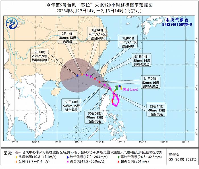
In addition, the 11th typhoon "Anemone" was generated on August 28th this year. At 14 o’clock this afternoon, its center was located on the northwest Pacific Ocean about 930 kilometers northwest of Guam, and the maximum wind force near the center was 9 (23 m/s, tropical storm level). It is expected that Anemone will move to the north-north direction, and its intensity will increase slowly, and it will begin to affect the eastern waters of China on the night of September 1.
Latest wind and rain forecast
Gale forecast
From August 29th to September 3rd, affected by typhoons Sura and Anemone, there will be 6-8 winds and 9-10 gusts in the southern Yellow Sea, the East China Sea, the Taiwan Province Strait, bashi channel, most of the South China Sea, Fujian coast, the coastal areas in central and eastern Guangdong and the coastal areas in southern Taiwan Province, and 9-10 winds in the southern East China Sea, bashi channel, the northeastern South China Sea and the coastal areas in central and eastern Guangdong.

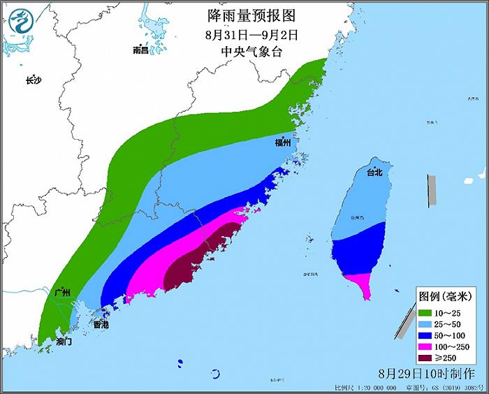
Rainfall forecast
Affected by Typhoon Sura and cold air moving southward, from August 31st to September 2nd, there were heavy rainstorms in central and southern Fujian, central and eastern Guangdong and Taiwan Province, heavy rainstorms in southeastern Fujian and southeastern Guangdong, and heavy rainstorms in coastal areas (the cumulative rainfall was 150-200mm, and the coastal area could reach 400mm), with the maximum hourly rainfall of 40-80mm.
Meteorologists reminded
Recently, typhoons are active, and typhoons Sura and Anemone will affect our country one after another. Sura may land in Guangdong with typhoon level or strong typhoon level. It is suggested that Guangdong and Fujian pay close attention to it and prepare for typhoon prevention in advance. Ships sailing in the sea area related to the typhoon route should return to Hong Kong in time to avoid the wind or the affected area, and the offshore operators should evacuate in advance; Fujian and Guangdong should pay attention to preventing mountain torrents, geological disasters and floods in small and medium-sized rivers, and strengthen the safety management of coastal tourism, transportation and urban operation.