A total of 31 earthquakes were recorded by 14: 00 in Hutubi earthquake, Xinjiang.
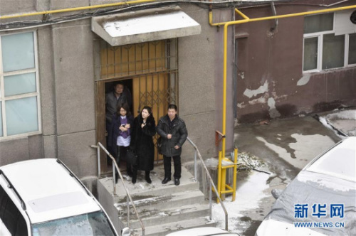
On December 8, citizens walked out of a building in Urumqi to prevent aftershocks. Xinhua News Agency reporter Zhao Geshe
BEIJING, Dec. 8 (Xinhua)-The China Seismological Network officially determined that a magnitude 6.2 earthquake occurred in Hutubi County, Changji Prefecture, Xinjiang at 13: 15 on December 8. Weibo, the official of Xinjiang Seismological Bureau, released the latest news. According to Queergou Town near the epicenter, a few houses in Sangong Township of Manas were cracked, and chimneys collapsed nearby, so people had moved to the outdoors to take shelter.
China Seismological Network officially measured that an earthquake of magnitude 6.2 occurred in Hutubi County, Changji Prefecture, Xinjiang at 13: 15 on December 8, with a focal depth of 6 kilometers. The epicenter was located at 43.83 degrees north latitude and 86.35 degrees east longitude. As of 14: 00 on December 8, a total of 31 earthquakes were recorded, including 0 earthquakes of magnitude 5.0 to 5.9, 0 earthquakes of magnitude 4.0 to 4.9 and 6 earthquakes of magnitude 3.0 to 3.9.
The earthquake is located in Hutubi County, 94km from Urumqi and 55km from Manas County. Since 1900, there have been eight earthquakes of magnitude 6 or above within 200km of the epicenter. The largest earthquake was the 1906 Ms7.7 earthquake, with a distance of 114km, and the nearest earthquake was the 1907 Ms6.0 earthquake, with a distance of 40km;. The latest earthquake in time is the June 30th, 2012 earthquake with a distance of 135km.
Hutubi County belongs to Changji Hui Autonomous Prefecture, located in the north-central part of Xinjiang Uygur Autonomous Region, in the hinterland of Eurasia, on the southern edge of Junggar Basin, 68 kilometers east of Urumqi, the capital of Xinjiang Uygur Autonomous Region.
Hutubi County is 258 kilometers long from north to south, with a maximum width of 52 kilometers from east to west and a total area of 9721.6 square kilometers. It governs 6 towns and 1 township: Hutubi Town, Dafeng Town, Queergou Town, Shilidian Town, Yuanhu Village and Town, Wugongtai Town and Shitizi Township. The county government is located in Hutubi Town.
At the end of 2012, Hutubi County had a total population of 217,300, including 25 ethnic groups including Han, Kazak, Hui and Uygur.
After the earthquake, the netizens in Urumqi, Changji, Turpan, Shihezi, Korla, Yili, Aksu, Emin, Karamay, Luntai and Bole all felt the earthquake.
At the same time, Weibo, the official of Xinjiang Seismological Bureau, released the latest news that Queergou Town near the epicenter reported that cracks appeared in a few houses in Sangong Township of Manas, and chimneys collapsed nearby, so people had moved to the outdoors to take shelter.
Wei Xiaoli, deputy director of Xinjiang Seismological Bureau, led eight staff members, including Sun Jianing, director of emergency department, five from Surveying and Mapping Institute and one from underground fluid center, to the epicenter at the first time.
The Seismological Bureau of China has decided to start the Class III emergency response, and the Seismological Bureau of Xinjiang Autonomous Region has started the Class II earthquake emergency response.
In addition, according to the emergency linkage mechanism of Seismological Bureau of China, Seismological Bureau of Gansu Province, Seismological Bureau of Ningxia Autonomous Region, Seismological Bureau of Qinghai Province and Seismological Bureau of Shaanxi Province will each send two emergency workers to the earthquake area to support emergency rescue work.